


Locus GIS Offline Land Survey
Description of Locus GIS Offline Land Survey
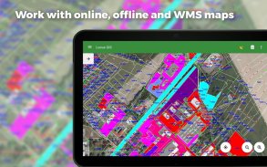
Professional GIS application for offline fieldwork with geodata. It provides data collection, viewing, and inspection with support for connection to external GNSS units achieving centimeter accuracy provided by an NTRIP client. All its features are available above a wide selection of online, offline, and WMS/WMTS maps.
Fieldwork
• Offline collecting and updating of field data
• Saving points with current location, by location averaging, projection, coordinates, and other methods
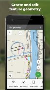
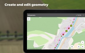
• Creating lines and polygons by motion recording
• Settings of attributes
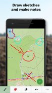
• Photos, video/audio, or drawings as attachments
• Setting out of points
• Boundary delineation
• Collecting location data for polygon/line recording or guidance on a target, even when the app is running in the background
Import/Export
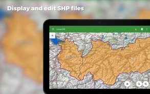
• Importing and editing ESRI SHP files
• Exporting data to ESRI SHP or CSV files
• Exporting whole projects to QGIS
• Support of third-party cloud storage (Dropbox, Google Drive and OneDrive)
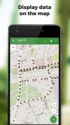
Maps
• Wide range of maps both for online use and for download
• Support of WMS/WMTS sources
• Support of offline maps in MBTiles, SQLite, MapsForge formats, and custom OpenStreetMap data or map themes
Tools and Features
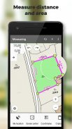
• Measuring distances and areas
• Searching and filtering of data in the attribute table
• Style editing and text labels
• Conditional styling - layer-based unified style or rule-based styling dependent on an attribute value
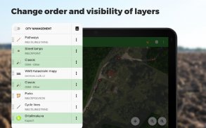
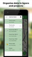
• Organizing data into layers and projects
• Templates for fast establishing of a project, its layers, and attributes
• Support for over 4200 global and local CRS (e.g. WGS84, ETRS89 Web Mercator, UTM...)
Advanced GNSS Support
• Support for external GNSS receivers for highly precise data collection (Trimble, Emlid, Stonex, ArduSimple, South, TokNav...) and other devices supporting Bluetooth and USB connection
• Skyplot
• NTRIP Client and RTK correction
• GNSS manager for managing receivers, and set up of pole height and antenna phase center
• Accuracy control - setup of minimum tolerance to collect valid data
Form Field Types
• Automatic point numbering
• Text/number
• Date and time
• Checkbox (yes/no)
• Ddrop-down selection with predefined values
• GNSS data (number of satellites, HDOP, PDOP, VDOP, accuracy HRMS, VRMS)
• Attachments: photo, video, audio, file, sketches, map screenshots
Locus GIS is successfully used in a wide range of industries:
Forestry:
• Forest inventory
• Tree mapping and inspections
• Mapping of species groups and vegetation
Environment
• Mapping plants and biotopes, presenting mappings and area delineations
• Faunal surveys, environmental impact assessments, monitoring of species and habitats
• Wildlife studies, plant studies, biodiversity monitoring
Surveying
• Searching for and viewing boundary marks
• Topographic surveys
• Land parcel surveying
Urban Planning and Mapping
• Updating road databases in the public works department
• Mapping and inspections of water pipelines and drainages
• Mapping of urban green spaces and inventory
Agriculture
• Agricultural projects and exploring natural resources, characterizing the soil
• Establishing agricultural land boundaries and identifying plot numbers, districts, and ownership limits
Other ways of use
• Gas and energy distribution
• Planning and construction of wind farms
• Exploration of mining fields and location of wells
• Road construction and maintenance
Locus GIS Offline Land Survey - Version 1.23.10
(14-02-2025)Locus GIS Offline Land Survey - APK Information
APK Version: 1.23.10Package: menion.android.locus.gisLatest Version of Locus GIS Offline Land Survey
Other versions


Apps in the same category

You may also like...


